

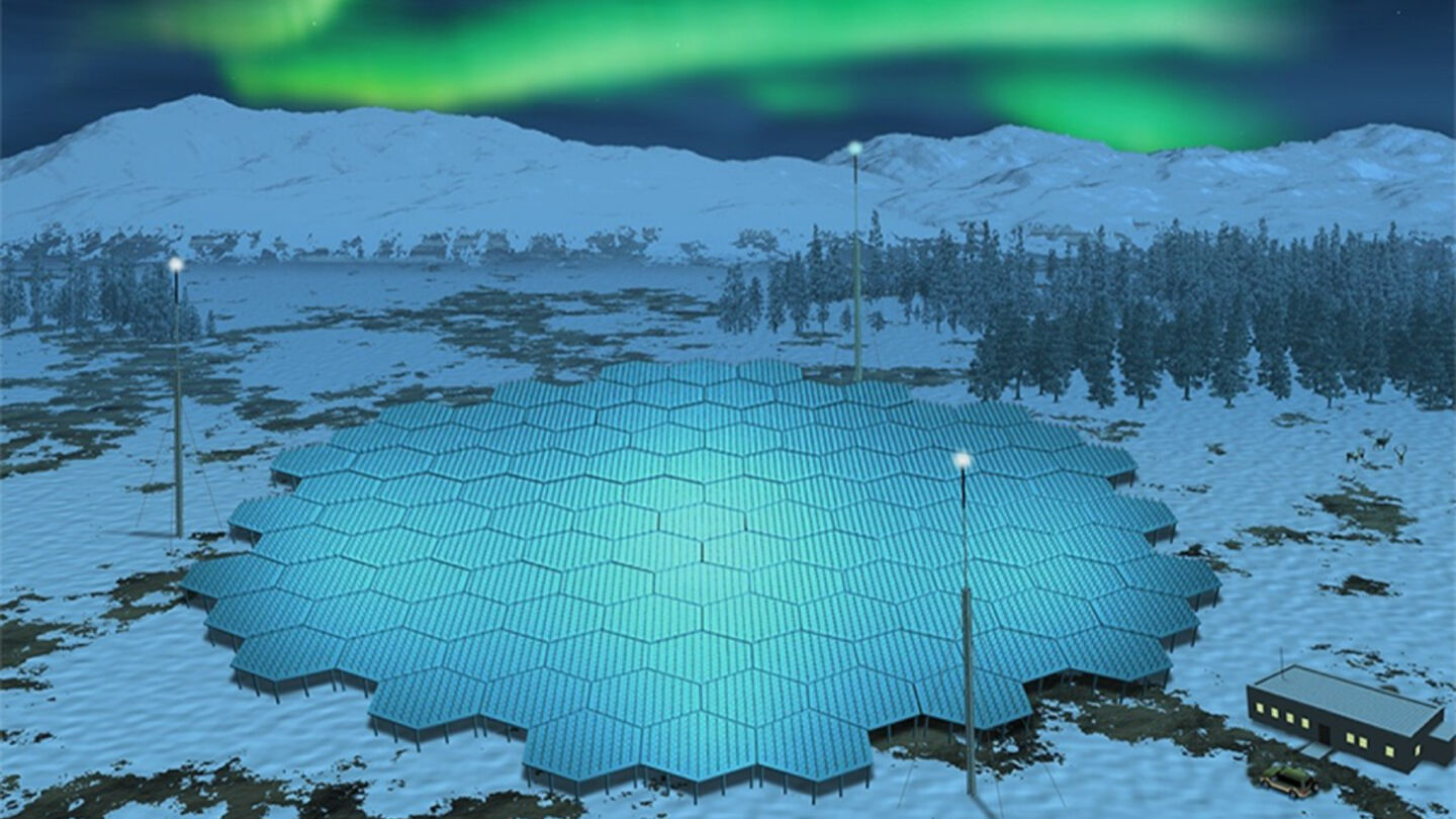
A research station consisting of 5,000 antennas is going up in Fell Lapland, and it will form with two other stations the only EISCAT_3D incoherent scatter radar of its kind. Space weather affects infrastructures, such as power grids, on the Earth’s surface in many ways, and scientists will gain new insights into the processes involved with the new radar system. Enontekiö is ideal for near-Earth space research.
The construction phase of the EISCAT_3D radar project began in 2017, and in May 2022 the antenna elements were sent to the Nordic countries. The antenna systems will be built in the Karesuvanto of the municipality of Enontekiö in Finnish Lapland, in Skibotn in Norway, and in Kaiseniemi in Sweden.
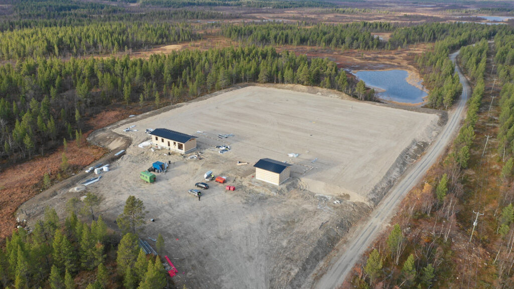
A research station building with facilities for working and maintenance is currently being built in Karesuvanto. The construction of the antenna field will begin in the autumn. According to the estimate, the research station will be operational in early 2023.
Unique incoherent scatter radar is the first in the world
The EISCAT organisation (European Incoherent Scatter Scientific Association) studies upper atmosphere phenomena and has large dish antennae radars in Sodankylä, Kiruna and Tromsø. Whereas current dish antennas collect data from only one direction at a time and their movement is mechanical and takes time, the new EISCAT_3D incoherent scatter radar collects huge amounts of data from many different directions at the same time. This means that the new system will make measurements much more efficient.
All three antenna fields in Finland, Sweden and Norway form a common system that makes it possible to produce a three-dimensional image of, for example, wind speed at 100–400-kilometer altitude. The thermosphere begins at an altitude of about 90 kilometers, with northern lights appearing at the bottom. Near-Earth space is thought to begin at the thermosphere.
Planning of the research project has been going on for more than ten years. The project will cost approximately EUR 70 million, of which EUR 12.8 million will be funded by the Academy of Finland. Sweden, Norway, the United Kingdom, Japan, and China are also involved.
3D radar is a major development for upper atmospheric research and the system is the only one of its kind in the world. The combination of three antenna fields can produce, for example, a three-dimensional image of the electrical currents of the northern lights. Until now, this has not been possible to achieve.
Understanding space weather is essential to humankind
What happens in space affects our lives on Earth, and that is why a better understanding of this is absolutely essential. This allows us to be better prepared for the problems caused by space weather. Space weather refers to changes in conditions in space. It is caused by, among other things, solar wind.
For example, space weather phenomena can make radio communication more difficult, confuse navigation devices or cause electrical disturbances. Thomas Ulich, Head of Observations at the Sodankylä Geophysical Observatory, points out that Finnair, for example, has had to change the route of Asian flights to travel near the polar region, and GPS and radio are absolutely essential tools for air traffic, so it is important to anticipate the effects of space weather.
Solar eruptions can damage and overload electrical systems over a wide area. By monitoring eruptions, it is possible to anticipate and predict major phenomena and minimise damage. The information can also be used to design infrastructure to better withstand the interference caused by space weather.
Many things depend on satellites, countless numbers of which are situated in near-Earth space. Space weather also affects satellites.
– People are becoming more interested in space weather as satellites become increasingly important, Ulich says and continues: –Near-Earth space is very important to us.
There are many things to explore over different time periods. EISCAT_3D reveals what is happening right now; for example, it can indicate where the northern lights can be seen; but it can also be used to see long-term phenomena, such as how the effect of space on the upper atmosphere and the upper atmosphere itself has changed over several years.
Enontekiö is suitable for cutting-edge research
Karesuvanto’s “Northern Lights Radar” takes up a hectare of space. One antenna field is about 80 meters in diameter and consists of 5,000 antennas. There is a lot of space in the north, but not every Arctic location is suitable as a place to set up a research station.
Lapland is an excellent location for atmospheric and near-Earth space research because phenomena such as solar wind and the resulting northern lights tend to occur in the polar regions of the Earth. Thomas Ulich says that another major reason for locating in Lapland is the existing functional and comprehensive infrastructure, unlike other Arctic places. The area is easily accessible, and the Nordics are democratic countries with a stable security environment.
For the incoherent scatter radar, scientists calculated what distances between stations would result in the best possible research outcome. The system requires electricity and a good network connection, so it was important to have an existing infrastructure ready. Karesuvanto turned out to be the perfect place. Due to the location of the Sodankylä Geophysical Observatory, the region already has experts in the field.
A suitable plot of land was found near the centre of the Karesuvanto village. Karesuvanto is in Fell Lapland, next to the Swedish border. Highway E8, which stretches all the way from Turku to Tromsø, passes through the area. In other words, you can continue north from Karesuvanto to Kilpisjärvi and the Norwegian border or travel to the other side of the Swedish border. Enontekiö Airport is only around 50 kilometers away.
The work of building an antenna field is demanding and meticulous. Antennas must not move a single millimetre out of position. Therefore, the effect of frost on the ground has been carefully investigated. Researchers also made sure that the activities do not interfere with reindeer herding and vice versa.
The multi-year project requires expertise in a wide range of fields, including mathematics, radar technology, atmospheric research, information technology and construction. In Finland, the project involves the University of Oulu and Sodankylä Geophysical Observatory, the Finnish Meteorological Institute, and CSC – the Finnish IT Center for Science.